


The USCG districts, spread throughout the entire USA, are responsible for maintaining navigational aids. They update over 54,000 navigation aids in the USA daily via the Local Notice to Mariners.
Additionally, the USCG provides a weekly update of the LNM, informing boaters about shoaling, dredging, events, and more.
Both services, daily and weekly, are included in the Aqua Map - USCG data service. The aim is to promptly inform captains about changes in navigational aids and provide details for a safe journey.
NOTE: An active Master subscription is required to access USCG data.
Coast Guard Settings
From the main Settings page, you can open the Coast Guard data settings page, where you can manage this feature.
Please note that on this page, you can manage data from various Coast Guard countries, currently including the United States and Canada.

At the top, there's initially a common section for managing the database:
- Download Coast Guard DB: This option enables the download and update of the Coast Guard database.
Note: As the label indicates, this information is available only in the US & Canada. - Update now: This button allows immediate downloading of the latest available database.
- Automatic update: You can choose the automatic update logic: "Never" will never update the database automatically (you shall press the "Update now" button manually), "WiFi" will perform an automatic daily update each time the app is active and connected to a WiFi network, and "Always" will update the database daily with any type of data connection (even cellular connection).
Note: With the "Always" option, you may incur extra costs depending on your mobile contract.
Then there is the United State section:
- Enable U.S. Coast guard data on map: This option displays the USCG data on the map.
- Icon size on Map: Choose the preferred icon size for USCG navigation aids.
- NOAA Buoys display: Select how to display the standard NOAA Navigation aids when the USCG buoys are shown. This option is useful because most of the NOAA buoys will "conflict" with the USCG buoys, as NOAA uses the USCG Lights List but updates them much less frequently. You'll find USCG navaids more accurate.
Here you can find out more about the data for Canada (see NAVWARNs).
Lights List
Once you activate the USCG Data, you will notice on the map all buoys, beacons, and lights provided by the USCG. They use icons similar to NOAA's, but with some additional info (e.g., ![]() ). Each icon has a small USCG flag at the bottom to distinguish it from standard NOAA symbols. Additionally, an optional circle icon may appear at the top-left to indicate specific situations:
). Each icon has a small USCG flag at the bottom to distinguish it from standard NOAA symbols. Additionally, an optional circle icon may appear at the top-left to indicate specific situations:
 Navigation alert: Indicates a potential navigation hazard in this area.
 Missing aid: Indicates that a buoy should be present but is currently missing.
 Out of position aid: Signals that a buoy has moved from its expected position.
 General information: Provides useful navigation information.
 Temporary aid: Indicates a temporary buoy that will be removed soon.
Tapping on a USCG buoy provides more information about that object.

Local Notice to Mariners (LNM)
In Aqua Map, you can also access the Local Notice to Mariners (LNM) published by the USCG, which pertains to specific areas.
LNM info page
Tap anywhere on the map, and if there is an LNM (or more) related to that area, it will be listed in Map Information.
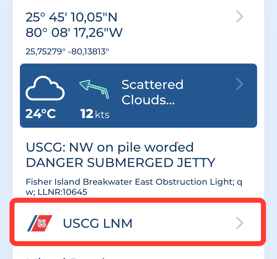
Select the "USCG: LNM info" to view details:

LNMs can contain information about General Notices, Advance Notices, Shoaling, Dredging, and Events. You can check them using the menu available at the bottom of the USCG LNM info page (as shown above).
LNM search
Go to the Search page, then choose the "Places and POIs" tab. From there, select the USCG LNM option in the "Search filters" and enter your search query.


In the example above, you are searching for all the LNMs that contain the word "Jupiter".

